Welcome to Nutbourne.Org, a community website for the Sussex hamlet overlooking England's South Downs. The site was created by local people predominantly for local people, but everyone's welcome!
Please click a menu option
Please click a menu option Welcome, news and events in and around Nutbourne Please click a menu option Nutbourne Residents' Association, Neighbourhood Watch and Local Affairs Please click a menu option A thousand years of Nutbourne and Pulborough history Please click a menu option Visiting, shopping or just enjoying Nutbourne in picturesque West Sussex Please click a menu option Join in, contribute pictures and stories, get in touch or search the site Please click a menu option Contributor credits, information about the Nutbourne Residents Association, the Website and its publisher Please click a menu option
 

Maps

Saxon Pulborough
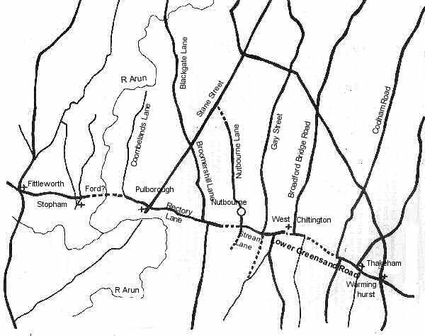
A map of Pulborough and the surrounding area in Saxon times (Copyright: Jack Pedley)

North-South Drove Roads, the Lower Greensand Road and Early Settlement
Drove roads linked villages in southern Sussex to their Wealden pastures in the north of the county. Settlers were attracted to the most fertile soils like the Sandgate Beds of the Lower Greensand Ridge on which Pulborough village sits. An east-west road developed along the ridge, referred to here as the Lower Greensand Road. It linked a long series of villages, hamlets and farms which tended to grow on crossroads with the drove roads. The junction of Stane Street (now a drove) and Rectory Lane/Church Place is just such a site. It is also a convenient location for the establishment of a new church, St Mary's after 680.

© Jack Pedley

Shortcuts to the maps in our collection

Roman Pulborough  Saxon Pulborough  Early Medieval Pulborough  Late Medieval Pulborough  Abergavenny Estate c1800  

Tithe Map 1841  Victorian Times 1892


© Copyright Nutbourne Residents Association and friends, 2016.